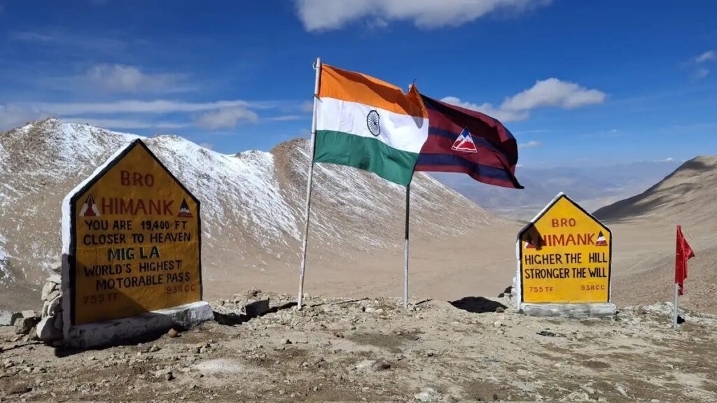
Nestled deep within the remote, high-altitude landscape of eastern Ladakh lies the newly established Mig La Pass, now recognized as the world’s highest motorable road. Rising to about 19,400 ft (5,913 m), this remarkable route surpasses even Umling La and the Everest Base Camps — redefining what’s possible in high-altitude engineering and adventure.
Built by the Border Roads Organisation (BRO) under Project Himank, the Likaru–Mig La–Fukche axis not only strengthens India’s frontier connectivity but also opens an exciting new chapter in Himalayan adventure tourism.
In this guide, let’s explore the geography, engineering brilliance, travel potential, challenges, and the emotional significance of this record-breaking pass — a true symbol of human ambition meeting Himalayan grandeur.
Location & Context: Where Is Mig La Pass?
Mig La Pass lies in the Leh district of Ladakh, on the Likaru–Mig La–Fukche road axis. It connects the region near Hanle to the border village of Fukche, located just about 3 km from the Line of Actual Control (LAC) on the India–China border.
Key Facts:
Altitude: ~19,400 ft (5,913 m) — higher than Umling La (19,024 ft).
Comparison:
South Everest Base Camp, Nepal – 17,598 ft
North Everest Base Camp, Tibet – 16,900 ft
Region: High-altitude Changthang Plateau of eastern Ladakh – cold desert terrain, sweeping vistas, sparse settlements, and immense strategic value.
Engineering Marvel & Strategic Importance
Constructing a motorable road at nearly 6,000 meters is an extraordinary feat. The BRO’s Project Himank achieved this milestone despite extreme challenges:
Oxygen levels at half of sea-level values – tough for both men and machines.
Harsh weather: sub-zero temperatures, snowstorms, and fierce winds.
Terrain: loose soil, permafrost, alpine desert, and steep gradients.
Logistics: transporting heavy machinery and maintaining roads amid freeze-thaw cycles.
Strategic Significance
Offers a third vital route linking Hanle to Fukche.
Enhances defense logistics and connectivity near the border.
Provides remote Ladakhi communities with improved access to essentials, healthcare, and communication.
Record-Breaking Legacy
The BRO’s achievement continues Ladakh’s proud high-pass lineage:
Weather: Rapid changes; storms and snow possible even in “summer.”
Travel Tips
Never attempt solo on first try — join a guided group.
Respect the environment and local regulations.
Stay informed on access status — “highest road” doesn’t always mean open road.
Focus on the journey — remote villages, nomadic life, and unmatched silence await.
The View, The Vibe & The Experience
At Mig La, you stand nearly 6 km above sea level — above the treeline, among whispering winds and endless skies.
Landscape
Stark, beautiful high-altitude desert with snow-clad peaks.
Prayer flags fluttering in icy winds.
Vast solitude — where human presence feels small yet purposeful.
Emotional Resonance
The “you made it” feeling is powerful here.
Mig La embodies both adventure and vulnerability — life at the edge of the inhabitable world.
Beyond geography, it’s a symbol of resilience and unity — of people, soldiers, and engineers who make the impossible possible.
Safety, Responsibility & Sustainability
High-altitude travel demands more than courage — it needs care and respect.
Health & Altitude
Altitude sickness risk above 3,500 m — acclimatise well.
Carry basic meds, oxygen cylinder, hydrate, and avoid alcohol.
Environment & Culture
Fragile ecosystem: avoid littering, stay on designated tracks.
Respect local customs and livelihoods of Changpa nomads.
Choose eco-friendly travel and local homestays.
Vehicle Readiness
Service your vehicle — brakes, tyres, cooling, fuel system.
Carry toolkit, puncture repair, and backup supplies.
What the Future Holds
Mig La Pass is more than a record — it’s a vision for the future.
For Local Communities
Enhanced access to healthcare, education, and markets.
Boost in sustainable tourism and income opportunities.
For Tourism & Adventure
A new Himalayan destination for explorers.
Routes diversify beyond Nubra, Pangong, or Leh–Manali.
Promotes responsible high-altitude travel.
For Engineering & Inspiration
A triumph of human determination and technology.
Extends India’s frontier infrastructure and global recognition.
Symbolically, a testament to India’s resilience in the world’s toughest terrains.
Final Thoughts
Standing at Mig La Pass is standing on the threshold of the extraordinary. It’s where the sky meets ambition, where silence humbles, and where every traveler feels a rare mix of awe and achievement.